14.50.430.02 Regulations.
A. General Regulations.
1. Whether or not a shoreline permit or written statement of exemption is required, the provisions of this section shall apply to all uses, alterations or developments within shoreline jurisdiction or shoreline buffers. All shoreline uses and activities shall be located, designed, constructed and managed to protect the ecological functions and ecosystem-wide processes provided by critical areas and shoreline vegetation.
2. The critical areas regulations found in Chapter 14.100, except as modified by Section 14.50.910, Appendix 2: Critical areas regulations, are integral and applicable to the SMP. All uses and development occurring within critical areas or their buffers within shoreline jurisdiction shall comply with these regulations.
3. If there are any conflicts or unclear distinctions between the provisions of Section 14.50.910, Appendix 2: Critical areas regulations, and this section, the requirements most consistent with the SMA and most protective of the resource shall apply, as determined by the shoreline administrator.
4. Within shoreline jurisdiction, critical area review, approval, notice and appeal periods/processes shall be integrated with the associated shoreline permit or exemption found in Article 7, Shoreline administration.
5. Within shoreline jurisdiction, applicants seeking relief from the provisions of Section 14.50.910, Appendix 2: Critical areas regulations, shall apply for a shoreline variance under Section 14.50.730.03.
6. The provisions of Section 14.50.910, Appendix 2: Critical areas regulations, do not extend shoreline jurisdiction beyond the limits specified in Section 14.50.060, Shoreline jurisdiction.
B. Shoreline Buffer Table.
1. The required critical area buffers for WDFW Type S waters shall be considered shoreline buffers, as established by Table 4-1, Shoreline Buffers.
2. The buffers for all other critical areas shall be established in accordance with the standards found in Section 14.50.910, Appendix 2: Critical areas regulations. If buffers for two (2) contiguous critical areas overlap, such as buffers for shorelines and wetlands, the wider buffer applies.
3. New uses and development that are not water-dependent, water-related, water-enjoyment or accessory to water-dependent, water-related or water-enjoyment uses or development or that do not facilitate public access to waters of the state generally will not be authorized in shoreline buffers, except those uses and activities allowed in subsection (D)(1) of this section.
4. Table 4-1: Shoreline Buffers establishes shoreline buffers by shoreline environment designation.
5. Shoreline buffers are measured landward from the OHWM in a horizontal direction perpendicular to the OHWM.
6. “N/A” in Table 4-1: Shoreline Buffers means the requirement is not applicable.
7. Subcategories for types of uses or activities include the following terms:
a. “Water-dependent” means a use that cannot exist in any other location and is dependent on the water due to the intrinsic nature of its operations, such as a port or sewer outfall.
b. “Water-related” means a use that is not intrinsically dependent on a waterfront location but whose economic viability is dependent upon a waterfront location, such as a fish processing plant or a sewer treatment plant.
c. “Water-enjoyment” means a recreational use or other use that facilitates public access to the shoreline as a primary characteristic of the use. Examples include public trails, golf courses, parks, etc.
d. “Non-water-oriented” means those uses that are not water-dependent, water-related or water-enjoyment, such as: a grocery store, etc.
8. The minimum shoreline buffer from the OHWM for a particular use is determined by finding the use and the most appropriate subcategory row and then finding the intersection with the appropriate shoreline environment designation column.
9. Building setbacks of fifteen (15) feet are required from the landward edge of the shoreline buffer. Building setbacks are used to protect the shoreline buffer from disturbance during construction and from the impacts related to use of a structure.
|
Shoreline Buffer from the OHWM (1) |
High Intensity |
Shoreline Residential |
Urban Conservancy |
Aquatic |
|---|---|---|---|---|
|
Agriculture (New Agricultural Activities Only) |
||||
|
Water-dependent structures and uses |
N/A |
0 feet |
0 feet |
N/A |
|
Water-related and water-enjoyment mixed-use structures and uses |
N/A |
75 feet |
75 feet |
N/A |
|
Non-water-oriented structures and uses |
N/A |
150 feet |
150 feet |
N/A |
|
Aquaculture |
||||
|
Water-dependent structures and uses |
0 feet |
0 feet |
0 feet |
N/A |
|
Water-related and water-enjoyment mixed-use structures and uses |
75 feet |
75 feet |
75 feet |
N/A |
|
Non-water-oriented structures and uses |
150 feet |
150 feet |
150 feet |
N/A |
|
Boating and Water Access Facilities |
||||
|
Water-dependent structures and uses |
0 feet |
0 feet |
0 feet |
N/A |
|
Water-related and water-enjoyment mixed-use structures and uses |
75 feet |
75 feet |
75 feet |
N/A |
|
Non-water-oriented structures and uses |
150 feet |
150 feet |
150 feet |
N/A |
|
Commercial Development |
||||
|
Water-dependent structures and uses |
0 feet |
N/A |
N/A |
N/A |
|
Water-related and water-enjoyment mixed-use structures and uses |
75 feet |
N/A |
N/A |
N/A |
|
Non-water-oriented structures and uses |
150 feet |
N/A |
N/A |
N/A |
|
Forest practices (2) |
N/A |
N/A |
150 feet |
N/A |
|
Industrial and Port Development |
||||
|
Water-dependent structures and uses |
0 feet |
N/A |
N/A |
N/A |
|
Water-related and water-enjoyment mixed-use structures and uses |
75 feet |
N/A |
N/A |
N/A |
|
Non-water-oriented structures and uses |
150 feet |
N/A |
N/A |
N/A |
|
Mining |
150 feet |
N/A |
N/A |
N/A |
|
Parking (accessory to a permitted use only) |
150 feet |
150 feet |
150 feet |
N/A |
|
Recreational Development (3) |
||||
|
Water-dependent structures and uses |
0 feet |
0 feet |
0 feet |
N/A |
|
Water-related and water-enjoyment structures and uses |
75 feet |
75 feet |
75 feet |
N/A |
|
Non-water-oriented structures and uses |
150 feet |
150 feet |
150 feet |
N/A |
|
Residential development |
150 feet |
150 feet |
150 feet |
N/A |
|
Signs (freestanding structures) |
150 feet |
150 feet |
150 feet |
N/A |
|
Transportation Facilities |
||||
|
Bridges and trestles |
0 feet |
0 feet |
0 feet |
N/A |
|
New transportation facilities related to permitted shoreline uses |
150 feet |
150 feet |
150 feet |
N/A |
|
Expansion or relocation of existing transportation facilities |
150 feet |
150 feet |
150 feet |
N/A |
|
Utilities (Primary) |
||||
|
Water-dependent structures |
0 feet |
0 feet |
0 feet |
N/A |
|
Water-related structures |
75 feet |
75 feet |
75 feet |
N/A |
|
Non-water-oriented structures |
150 feet |
150 feet |
150 feet |
N/A |
(1)Reductions in the shoreline buffer from the OHWM may be authorized according to the standards in subsection (C) of this section.
(2)Where the FPA applies, the stricter of the SMP or FPA buffer shall be used.
(3)Passive, water-oriented recreational uses are allowed within shoreline buffers; provided, the use does not include the construction of structures. Wildlife viewing structures, permeable trails or raised boardwalks may be allowed on a limited basis within riparian and wetland buffers in accordance with the mitigation sequence found in Section 14.50.420 and the mitigation requirements found in Chapter 14.100.
C. Standard Shoreline Buffer Width Reduction Options. Standard shoreline buffers may be reduced consistent with the mitigation sequence in Section 14.50.420 and the mitigation requirements found in Chapter 14.100, using the following procedures. Only one (1) buffer width reduction option may be utilized for a development proposal:
1. Shoreline Buffer Averaging.
a. The width of a standard shoreline buffer may be averaged, thereby reducing the width of a portion of the shoreline buffer and increasing the width of another portion of the shoreline buffer.
b. A mitigation plan shall be prepared by the applicant as outlined in Section 14.100.072. The applicant will need to demonstrate to the satisfaction of the shoreline administrator that the following criteria are addressed:
(1) The water body and associated shoreline buffer have significant differences in characteristics depending on location that affect their habitat functions;
(2) The shoreline buffer is increased adjacent to the higher functioning area of habitat or more sensitive portion of the water body and decreased adjacent to the lower functioning or less sensitive portion;
(3) The shoreline buffer averaging does not reduce the ecological functions or values of the water body and associated shoreline buffer or the shoreline buffer averaging, in conjunction with vegetation enhancement, increases ecological functions or values;
(4) The total area of the shoreline buffer after averaging is equal to the area of the required shoreline buffer without averaging and all increases in shoreline buffer dimension for averaging are generally parallel to the OHWM;
(5) The shoreline buffer at its narrowest point is never less than seventy-five (75) percent of the required width;
(6) The slopes adjacent to the water body within the shoreline buffer area are stable and the gradient does not exceed thirty (30) percent; and
(7) The applicant implements all feasible measures to reduce the adverse effects of adjacent land uses and ensure no net loss of ecological functions.
2. Common Line Provisions.
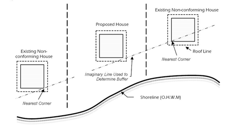
a. To accommodate adequate shoreline views comparable to adjacent existing residences, the shoreline administrator may reduce the standard shoreline buffer for a new single-family residence consistent with the following criteria:
(1) The proposed residence must be located in the shoreline residential shoreline environment designation and within one hundred fifty (150) feet of an adjacent legally established single-family residential primary structure that encroaches on the shoreline buffer. Accessory structures such as sheds or garages shall not be used to determine a common line shoreline buffer.
(2) For the purpose of this reduction, the nearest corners of the foundations of the adjacent residences are those closest to the side-yard property line of the proposed residence.
(3) Existing Residences on Both Sides. Where there are existing residences adjacent on both sides of the proposed residence, the common line shoreline buffer shall be determined as the greater of either:
(a) A common line drawn between the nearest corners of the foundations of each adjacent residence; or
(b) A common line calculated by the average of both adjacent residences’ existing setbacks from the OHWM.
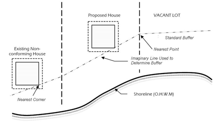
(4) Existing Residence on One (1) Side. Where there is only one (1) existing residence adjacent to the proposed residence, the common line shoreline buffer shall be determined as the greater of either:
(a) A common line drawn between nearest corner of the foundation for the adjacent residence and the nearest point of the standard shoreline buffer on the adjacent vacant lot; or
(b) A common line calculated by the average of the adjacent residence’s setback from the OHWM and the standard shoreline buffer for the adjacent vacant lot.
b. If the conditions in subsection (C)(2)(a) of this section are met, the applicant may prepare a mitigation plan as outlined in Section 14.100.072 and demonstrate to the satisfaction of the shoreline administrator that:
(1) A mitigation plan in accordance with Section 14.100.072 demonstrates that enhancing the shoreline buffer by removing invasive plants, planting native vegetation, installing habitat features, or other means will result in a shoreline buffer of a reduced width that functions at a higher level than the existing standard shoreline buffer; or
(2) Conditions unique to the site, including legally existing uses, developments established prior to the effective date of the SMP or naturally existing topographic barriers, exist between the proposed development and the OHWM, which substantially prevent or impair delivery of most natural functions from the subject upland property to the water body.
3. Reduction for Road or Railroads in Buffer (Applicable to Shoreline Buffers Only).
a. Where one (1) of the following crosses a standard shoreline buffer:
(1) A legally established road or railroad, excluding a private driveway;
(2) The expansion of existing roads and railroads; or
(3) Construction of new roads or railroads related to cargo handling and freight mobility (whether included as a portion of a large development or submitted as an individual project).
b. The shoreline administrator may reduce the standard shoreline buffer width to the waterward edge of the improved road or railroad. This reduction may only be granted if a qualified professional documents that the part of the standard shoreline buffer on the upland side of the road or railroad:
(1) Does not provide additional protection for the water body; and
(2) Does not provide significant biological, geological or hydrological functions for the waterward portion of the shoreline buffer adjacent to the OHWM of the water body.
4. Shoreline Buffer Width Reduction.
a. The width of a standard shoreline buffer may be reduced up to twenty-five (25) percent administratively if shoreline buffer averaging (subsection (C)(1) of this section), common line provisions (subsection (C)(2) of this section) or reduction for road or railroads in buffer (subsection (C)(3) of this section) are infeasible.
b. If the conditions in subsection (C)(4)(a) of this section are met, the applicant may prepare a mitigation plan as outlined in Section 14.100.072 and demonstrate to the satisfaction of the shoreline administrator that:
(1) A mitigation plan in accordance with Section 14.100.072 demonstrates that enhancing the shoreline buffer by removing invasive plants, planting native vegetation, installing habitat features or other means will result in a shoreline buffer of a reduced width that functions at a higher level than the existing standard shoreline buffer; or
(2) Conditions unique to the site, including legally existing uses, developments established prior to the effective date of the SMP or naturally existing topographic barriers, exist between the proposed development and the OHWM, which substantially prevent or impair delivery of most natural functions from the subject upland property to the water body.
D. General Buffer Regulations.
1. Shoreline Buffers. The following new uses and activities are allowed within shoreline buffers without a shoreline variance, when located, constructed, and maintained in a manner that minimizes adverse impacts on shoreline ecological functions, and when otherwise in compliance with this SMP:
a. Accessory Uses. Uses and development accessory to water-dependent uses shall be located outside the shoreline buffer unless at least one (1) of the following criteria is met:
(1) A location in the shoreline buffer is necessary for operation of the primary water-dependent use or development, such as a road to a boat launch facility; or
(2) The accessory use is on legally established public lands and is primarily related to access, enjoyment and use of the water; and the use does not conflict with or limit opportunities for other water-oriented uses.
b. Essential Public Facilities. Essential public facilities, as defined by RCW 36.70A.200, may be located and expanded in the shoreline buffer if the use cannot be reasonably accommodated or accomplished outside of the standard or reduced shoreline buffer.
(1) Proposals for essential public facilities must demonstrate that alternative sites that meet facility requirements are not available.
(2) These uses must be designed and located to minimize intrusion into the shoreline buffer and shall be consistent with the mitigation sequence in Section 14.50.420 and Chapter 14.100.
(3) Impacts to the shoreline buffer shall be fully mitigated.
c. Water-Oriented Education, Scientific Research and Passive Recreational Uses. These uses may include, but are not limited to, fishing, bird watching, hiking, hunting, boating, horseback riding, skiing, swimming, canoeing and bicycling. Such uses are allowed within shoreline buffers provided the use does not include construction, except as follows: wildlife viewing structures and permeable trails or raised boardwalks may be allowed on a limited basis within riparian and wetland buffers in accordance with the mitigation sequence in Section 14.50.420 and Chapter 14.100.
d. Site Investigative Work Necessary for Land Use Application Submittals Such as Surveys, Soil Logs, Drainage Tests and Other Related Work, Including Monitoring of Restoration or Mitigation Sites. In every case, shoreline buffer impacts should be avoided or minimized and disturbed areas shall be immediately restored.
e. Shoreline modifications in conformance with the applicable provisions found in Article 6, Shoreline Modification Policies and Regulations.
2. Critical Areas Buffers. The uses and activities allowed within critical areas buffers in Section 14.50.910, Appendix 2: Critical areas regulations, may be allowed without a shoreline variance, when located, constructed and maintained in a manner that minimizes adverse impacts on shoreline ecological functions and in compliance with the SMP.
E. Vegetation Conservation Standards.
1. Shoreline buffers protect the ecological functions of the shoreline, help to reduce the impacts of land uses on the water body or aquatic resource and provide a transition between aquatic and upland areas.
2. Authorized uses shall be designed to avoid removing existing native vegetation to the maximum extent feasible within shoreline and critical areas buffers consistent with safe construction practices and other provisions of this section. Any impacts to existing native vegetation must follow the mitigation sequence in Section 14.50.420 and comply with Chapter 14.100 as modified by Section 14.50.910, Appendix 2: Critical areas regulations and subsection (A) of this section.
3. Removal of vegetation within shoreline and critical areas buffers shall require a critical area report and/or a mitigation plan in coordination with the requirements of Section 14.100.072. The shoreline administrator may require a critical area report for critical areas regulations exempt activities if necessary to document compliance with the provisions in the SMP.
4. Removal of native vegetation from shoreline buffers must be compensated at a minimum 1:1 ratio, which the shoreline administrator may increase if necessary to assure no net loss of shoreline ecological functions. Increases may be necessary to compensate for temporal losses, uncertainty of performance and differences in ecological functions and values.
5. Mitigation ratios shall be based on a scientifically valid measure of habitat function, value and area. Critical area reports shall include a description of how the proposal complies with the mitigation sequence in Section 14.50.420 and how mitigation areas will be monitored and maintained to ensure no net loss of shoreline ecological functions.
6. Vegetation conservation standards shall not apply retroactively to existing, legally established uses and developments. Existing, lawfully established landscaping and gardens within shoreline jurisdiction may be maintained in their existing condition. In the context of this regulation, maintenance includes, but is not limited to, mowing lawns, weeding, removal of noxious and invasive species, harvesting and replanting of garden crops, pruning and replacement planting of ornamental vegetation or indigenous native species to maintain the condition and appearance of such areas.
7. Clearing of invasive, noxious nonnative vegetation in shoreline buffers is allowed by hand labor or with light equipment. Removal of noxious weeds as listed by the state in Chapter 16-750 WAC is allowed in a manner consistent with Washington State Noxious Weed Control Board regulations. Native vegetation shall be promptly reestablished in the disturbed area.
8. In shoreline buffers, pruning shall comply with the National Arborist Association pruning standards. Trees that are felled in shoreline buffers should be left in place. The exception to this regulation is that hazard trees, which are dead, diseased, leaning or structurally unsound trees that are deemed an emergency, may be removed at any time. Hazard tree removal is addressed in Section 14.100.050(B)(5)(c).
9. In those instances where the management of vegetation required by this section conflicts with provisions in state, federal or other flood hazard agency documents that govern licensed or certified flood hazard reduction measures, the requirements of the SMP will not apply. The applicant shall submit documentation of conflicting provisions with a shoreline permit application and shall comply with all other provisions of the SMP that are not strictly prohibited by certifying or licensing agencies.
F. Revegetation.
1. Surfaces that are cleared of vegetation in shoreline or critical area buffers, aside from normal maintenance described in subsection (E)(6) of this section, and are not developed must be replanted within one (1) year. Replanted areas shall be planted and maintained such that within three (3) years the vegetation cover is at least ninety (90) percent reestablished. Areas that fail to reestablish vegetation adequately shall be replanted with approved plant materials until the plantings are viable. Revegetation areas will be maintained in good growing condition and kept free of noxious weeds, and with removal of dead or dying plants, for a five (5) year monitoring period.
2. Vegetation shall be planted in similar quantities and species to what existed previously on the site to achieve no net loss of ecological function. Disturbed ornamental landscapes, including grass, may be replaced with similar species, unless mitigation is necessary to address project impacts.
3. Native plants are preferred for all revegetation. Nonnative species on the Grays Harbor County’s list of invasive species shall not be allowed.
G. Aquatic Vegetation Control.
1. Aquatic vegetation control shall only occur when native plant communities and associated habitats are threatened or where an existing water-dependent use is restricted by the presence of weeds. Aquatic vegetation control shall occur in compliance with all other applicable laws and standards, including the WDFW requirements such as the Aquatic Plants and Fish Pamphlet, which serves as the Hydraulic Project Approval (HPA) for some types of aquatic weed or plant control and removal.
2. The application of herbicides or pesticides in water bodies including Grays Harbor, lakes, wetlands or ditches requires a permit from Ecology and may require preparation of a SEPA checklist for review by other agencies. The applicator must have a pesticide applicator license from the Washington State Department of Agriculture.